
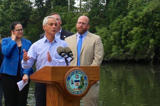
NORTH CENTER — Flanked by more than a dozen city officials and private partners, Mayor Rahm Emanuel unveiled his long-touted plan for development along Chicago's rivers Wednesday.
Encompassing all three of the city's rivers — the Chicago River, the Des Plaines River and the Calumet River — and charting more than two decades into the future, the 76-page plan calls for an intricate network of tourism, transportation and recreation to weave through the waterways.
Speaking on a floating dock in front of the WMS Boathouse at Clark Park, 3400 N. Rockwell Ave., Emanuel said he'd been "waiting for five years" to make the plan official.
RELATED: Take A Dip In The Chicago River? It Could Be Possible
"The vision laid out today for the next 40 years is our guiding principle, our North Star, on how to make the river ... a place not that people avoid, but where people go to enjoy," he said. "It's our opportunity to see the rivers not as a dividing line, but as a way to bring people together, and be unique as a city with two waterfronts."
The plan, titled "Our Great Rivers," sketches out a boost in riverfront attractions by 2020, continuous riverfront trails for cyclists and pedestrians by 2030, and "fully litter- and odor-free rivers" by 2040.
It would also dial in on environmental remediation and wildlife restoration, ideally making all the city's rivers safe and clean enough to swim in.
The following are some specific elements of the plan:
• A color-coded public notification system would show which parts of the river are safe for boating and swimming, depending on pollution and weather conditions.
• A "mixed use development" would be built where Ashland Avenue meets Bubbly Creek in McKinley Park, featuring "housing, retail and riverfront recreational activities." A pedestrian bridge will cross the creek where it meets the South Branch of the Chicago River.
The 19,000-square-foot Eleanor Street Boathouse is already under construction there, set to open by fall.
 A bird's-eye view of the proposed development and pedestrian bridge where Bubbly Creek meets the Chicago River in McKinley Park. [Metropolitan Planning Council]
• A trail along the Collateral Channel near Kedzie Avenue would link the Chicago Sanitary and Shipping Canal to La Villita Park in Little Village, eventually linking up with the planned Paseo trail. The plan predicts that the channel could become "a major hub of riverfront use" by "addressing odor issues and creating open space for recreation."
 A trail would follow the Collateral Channel linking the Chicago Sanitation and Shipping Canal to La Villita Park in Little Village. [Metropolitan Planning Council]
• The North Branch Canal on the east side of Goose Island would become a "wetland park and natural playground" for fishers and kayakers. A new pedestrian bridge would cross the canal just north of Division Street.
 The North Branch Canal along Goose Island envisioned as a "wetland park and natural playground." [Metropolitan Planning Council]
• A 56-mile trail along the Des Plaines River would "wind through forest preserves among hotels, offices and homes in Chicago and suburbs."
 The plan calls for a 56-mile trail to snake along the Des Plaines River. [Metropolitan Planning Council]
• On the city's Southeast Side, an additional network of trails along the Calumet River would join the Major Taylor Bike Trail and Cal-Sag Trail. Lake Riverdale, currently hidden between two huge rail yards in South Deering, would be "restored to ecological health" and turned into a "living marsh" accessible to visitors.
 Alongside a host of new trails following the Calumet River, Lake Riverdale would become a "living marsh." [Metropolitan Planning Council]
"All of these are old industrial transportation models that will now be converted into new parks," Emanuel said. "The rivers became our industrial highway, and now we're going to reclaim it...as our recreational frontier for generations to come."
Emanuel said the improvements will be paid for by a mix of Chicago Park District funds, Tax Increment Financing, private investments and grants from the state and federal government. Since the plan was previewed, he added, more than $6 million in private development has already been planned near the Chicago River.
"In the years to come, [the funding plan] will probably be studied by some business school," he said with a chuckle.
For more neighborhood news, listen to DNAinfo Radio here:


