Photo credit: Daily Overview | Image (c) 2016, DigitalGlobe, Inc.
(You can zoom in to this image to focus on neighborhood details.)
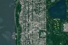
WASHINGTON HEIGHTS — You can spot the never-ending traffic along the George Washington Bridge from miles away — even from a satellite 400 miles up.
The bridge, which first opened in 1931, is the epicenter of Uptown and is one of the main east-west thoroughfares shuttling people between New York and New Jersey.
Even when it's not allegedly being ordered shut down for political revenge, the GWB's capacity for gridlock is legendary. And here's photographic evidence: You can see the traffic from space, according to overhead images from Daily Overview.
The bridge isn’t the only landmark that steals the show. From way up, the Diamond-shaped roof of the George Washington Bridge Terminal, which has been undergoing a renovation project for eight years, is immediately spottable, as are the two turquoise discs of the The Highbridge Pool and Recreation Center on Amsterdam Avenue at 173rd St., which opened shortly after the bridge in 1936 and features two outdoor pools.
Fort Washington Park and Highbridge Park add a pop of green while the Castle Village co-ops along Cabrini Boulevard near 181st Street, provide a geometric grid of distinctly orange-capped tops near Fort Washington Park.
This story is part of DNAinfo's Neighborhood Portrait feature, a collection of images that captures and celebrates the uniqueness and beauty of our neighborhoods. In addition to photos from our neighborhood reporters, we’ve partnered with Daily Overview to showcase their unique satellite photography. You can sign up to receive more stunning photos from the Neighborhood Portrait series delivered directly to your inbox.