

We’ve rounded up the best navigation and transit apps for you to use if Google and Apple Maps leave you cold:
► Transit App
Featured languages include English, French, German, Italian and Spanish.
Devices: Android, iPhone, iPad, iPod Touch
Price: Free

Transit App convenes virtually all potential transit options in one central location.
Use its real-time maps and offline schedules to better plan your next subway trip in more than 100 cities in North America and Europe, or hit up its bike share data feature to see where the nearest bike share station is, as well as how many bikes and docks are available.
If you're feeling wealthy, you can also look up nearby Car2Go spots, as well as request an Uber in just two taps.
►Moovit
Devices: Android, iPhone, iPad, iPod Touch
Price: Free

Moovit describes itself as the “latest weapon in the fight against transit interruptions, delays and line adjustments that affect your trip,” and it seems to be a pretty sharp one.
Like other apps listed here, Moovit offers live updates of service interruptions, transit personalization options and GPS to identify the best routes to take to your destination.
Moovit adds another, less common feature: crowdsourced updates on everything from station cleanliness to crowdedness, provided by other Moovit users.
Moovit, which can be used in more than 30 languages and 100 cities across the United States, blends this real-time “community powered” information with complete schedules and official transit information to present a more realistic portrait to app users.
►Citymapper
Devices: Android, iPhone, iPad, iPod Touch
Price: Free
Citymapper can be used by English, French, German, Italian, Japanese, Portuguese and Spanish speakers.

Described by The New York Times as “the best travel app to be introduced to New York City,” Citymapper offers simple A to B trip planning on all modes of transit, as well as service disruption alerts, hyperlocal weather updates, and personalization features so you can stay updated on travel conditions to your favorite places. As with Transit App, Citymapper is integrated with Uber.
►Exit Strategy
Devices: Android, Blackberry, iPhone, iPad, iPod Touch
Price: $3.99
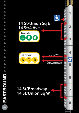
Hate the extra minutes that picking the wrong train car adds to your commute? Exit Strategy is here to help. When you enter your destination into the app, it tells you exactly where you should be on the train (from which car you should enter down to on which side of the car you should stand), so you can be as close to your desired exit as possible.
The app also features official MTA subway and bus maps, as well as a comprehensive map of Manhattan. Since Exit Strategy doesn’t need phone service or Internet to function, you can change destinations underground and still use its time-saving services.
►iTrans NYC Subway
Devices: iPhone, iPad, iPod Touch
Price: $3.99
The app is available in English, French, German, Italian, Japanese, Simplified Chinese and Spanish.

Featuring live train times that let you know exactly when a numbered-line train will arrive, an offline mode for underground navigation service and customized delay push alerts, iTrans NYC Subway is perfect for the traveler who might not know exactly where they want to go, except for the fact that they want to go there quickly.
For those who need as much help walking around the city as they do navigating its public transit system, the app also features walking directions and subway entrance/exit data so you can avoid that extra “I don’t know which exit to take” block.
►NYC Subway 24-Hour KickMap
Devices: iPhone, iPad, iPod Touch
Price: $2.99, $3.99 for iPad

If you find MTA maps to be more confusing than they are helpful, KICK Design’s map is a must-download. With a stated goal of reducing automobile use in the city, KickMap blends the best components of both topographical and diagrammatic maps into one clear, hybrid map system.
At each station, the map-app lets users know what train stops are there and when they stop; whether riders can cross over to go in the opposite direction for free (many don’t); where there is wheelchair access as well as a commuter train.
Additionally, the app can work without an Internet connection and includes a GPS locator for finding close subway stations, as well as customized transit alerts.


