STATEN ISLAND — Advocates pushing for pedestrian and bicycle access across the Verrazano-Narrows Bridge have published a map of trails along New York Harbor.
The Harbor Ring, started by volunteers from Transportation Alternatives, published the map of a 50-mile pedestrian and bicycle ride that takes people through Manhattan, Staten Island, Brooklyn and parts of New Jersey.
While the map was already available on Google maps, Paul Gertner, chairman of Harbor Ring, said one his group published last week makes it easier for riders to view and print the route.
"It's the same route that was on our original map, which was basically traced over a Google map," Gertner said. "Now it's all very functional and it's easy to read. It's really a professionally typed map."
The group raised money with an Indiegogo campaign to have the map professionally drawn up. They then published it on their website.
The group plans to print hard copies of the map within the next two months to hand out to bicycle shops and rental places.
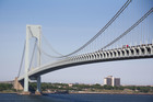
With the new version of the map published, Gertner said the group has increased its push for the MTA to get bicycle and pedestrian access on the Verrazano Bridge, a key component of the route.
Gertner said the MTA told the group in April they're considering starting a study to look at the feasibility and cost of putting the route in, but has been silent since.
"Six months later and nothing happened, it's time for a response," he said. "We're not going away, we're just going to keep at it."
The MTA said there's currently no capital plan to build the paths, which would need a study that wouldn't start until 2014.
"A feasibility study, addressing a host of issues including cost, structural issues, operational issues and impact on the surrounding neighborhoods would have to be conducted," said Judie Glave, a spokeswoman for the MTA.
"MTA Bridges and Tunnels is considering studying this issue as part of a future reconstruction project. Such a study would not begin until 2014 or later."
Mid-Island City Council candidate John Mancuso recently called on the MTA to include plans for the path when they start reconstruction on the upper level of the bridge.