
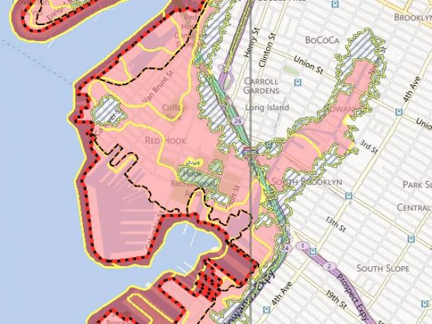
BROOKLYN — The Federal Emergency Management Agency (FEMA) has recently published expanded flood-risk zones in Red Hook and Gowanus to their Advisory Base Flood Elevations maps.
These flood elevation maps show a more current picture of flood risk for areas that were affected by Hurricane Sandy, according to FEMA. They are typically considered more accurate than their Flood Insurance Rate Maps, which are more than 25 years old, in some cases.
While the new maps are still in an advisory stage and will not officially be in use for another one or two years, they will eventually be used to update FEMA’s Flood Insurance Rate Maps.
FEMA encourages communities to adopt the advisory maps as “the best available flood hazard information,” according to the agency.
The redefined section of the map shows vulnerable areas in Red Hook and Gowanus marked as “Zone A.” Properties in these areas should be raised 3-feet above the “Base Flood Elevation” to avoid paying high premiums in Federal Flood Insurance.
According to FEMA, the premium for a property 4 feet below the base flood elevation level could be $9,500 per year, as opposed to $427 per year, if raised 3 feet above the level.
Although the updated maps are not officially in use, “...I feel property owners in affected areas need to know right now what is being planned because it will greatly impact your plans for rebuilding,” according to a statement from State Senator Velmanette Montgomery, who represents the District 25 of the Senate, which includes Red Hook and Gowanus.
To determine the current and advisory flood risk of your property, visit this website.


