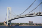
STATEN ISLAND — Bike paths across the Verrazano-Narrows Bridge — or even a completely new span underneath the existing one — could link Brooklyn and Staten Island, according to proposals being discussed.
The MTA is studying the possibility of adding bike and pedestrian access to the bridge as part of a "Master Plan" of improvements and repairs to the aging bridge, according to Bernard Kalus of Parson Brinckerhoff WSP, the group contracted to create the plan.
The firm came up with three options for access — bicycle and pedestrian lanes on either side of the lower or upper level for the bridge and a bridge underneath the Verrazano just for people walking or riding bikes — but the group would have to continue to study the feasibility of the proposals.
"What the 'Master Plan' would do is lay out a roadmap to identify the issues and what are the steps to further that evaluation," Kalus said.
Each option would cost between $300 to $400 million to complete and the agency will not be able to determine the feasibility of adding them until the end of the "Master Plan" study in 2016. Several factors stand in the way of the bike lanes, including the weight of the bridge and wind conditions.
"The primary challenges are the additional weight that is added to the structure and the need to balance that with the existing weight of the structure," Kalus said.
"Also the wind effects of having new structural elements on the suspension portion of the bridge and then you also have the access on either side of the bridge."
The entire "Master Plan" looks at spending $1.5 billion to rehabilitate the roadways of the 50-year-old bridge and make improvements to the exit and entrance ramp on the Brooklyn side. It also includes a roadmap for replacing the lower level of the bridge, which Kalus said needs to happen in 15 to 20 years.
The only part of the plan funded in the MTA's Capital Plan for 2015 to 2019 is the first phase, which improves the Lily Pond Avenue exit before the bridge, rehabs the upper level approaches on the Brooklyn and Staten Island sides, widens and reconstructs the lower level left exits to the Belt Parkway and the preliminary design for the lower level reconstruction, Kalus said.
The other phases include changing the upper level exit to the Belt Parkway from the right lane to the left lane and numerous improvements to exit ramps for drivers headed to the Gowanus and 92nd Street exits.
As part of the lower level replacement, which poses challenges to the agency because of the limited space to work, the firm started to look into if adding bicycle and pedestrian access to the bridge was possible — something bike advocates have long petitioned for.
The addition of the lanes would only be possible on the side of the bridge or underneath because they can't take away lanes for cars, and they would need to shave off 12,000 tons from it to accommodate them.
The agency recently replaced the upper level with lighter, but stronger, steel roadways. Kalus said to add bike lanes, engineers would need to figure out a way to cut 12,000 tons from the existing span as the weight has to stay the same.
To maintain balance, they would need to build ramps on both sides of the bridge and proposed having one side for bikes and the other for pedestrians.
Aside from the weight issues, the agency would need to study wind impact on riders and the potential to have to close access during certain weather conditions.
Another issue in the way of the lanes would be the land acquisitions needed to build entrances for bikes and pedestrians on both sides of the bridge from the state and city Departments of Transportation and the Parks Department, Kalus said.
The group has already started meeting with the agencies to get feedback on the project.
On the Brooklyn side, riders would need to climb 150 feet to get to the lower level of the bridge and 60 feet on the Staten Island side. The agency would need to build ramps for bikes and switchback ramps in the John Paul Jones Park in Bay Ridge and on New York Avenue in Fort Wadsworth.
The separate bridge, which would be off to one side under the Verrazano, would also need a way to raise the middle to allow ships to pass through and all options can not change the curvature underneath for boats, the agency said.
The group has met with elected officials in Staten Island and Brooklyn and plans to meet with transportation advocates and community boards before finishing the master plan.