
ASTORIA — A map unearthed by researchers in the United Kingdom could offer a unique look at British-occupied New York City during a crucial chapter of the Revolutionary War — if it proves to be authentic.
The map was brought to light by Andrew Adamson who founded Heritage Charts, a British company that finds documents in archives and sells high-quality reproductions, including original surveys made by early British cartographers.
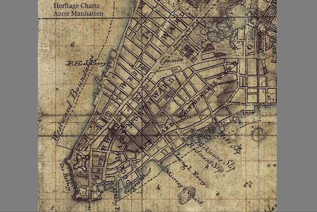
A few years ago, Adamson was looking through archives at the United Kingdom Hydrographic Office in Somerset, England, when he came across a "very brown and dusty plan" that showed New York City and its surrounding areas.
"What was of immediate interest was the inclusion on the map of British troop positions, including General Howe's headquarters at Newtown, Long Island," Adamson told DNAinfo New York via email.
Based on those troop positions, Adamson surmised that the map showed British-occupied New York in the summer of 1776, the period between the Battle of Brooklyn and the Battle of Harlem Heights. Adamson said he believes the document was part of a working military field map at the time.
Also of interest to Adamson was a second, smaller piece of paper at the center of the map that shows Manhattan in great detail. He said he believes this sheet is a drawing by Bernard Ratzer — a famous cartographer of that period — that was copied and used to make a larger, well-known Ratzer map of New York that was published in 1776.
"If I am correct, this is the near equivalent of finding Leonardo's sketch for the Mona Lisa!" Adamson wrote.
The rest of the map Adamson found was less carefully drawn, and he believes the smaller piece of paper was used as a starting point for other surveyors to sketch out the rest of it. He also believes the document is one portion of what was once a much larger map, since its edges are frayed.
Convinced he had found something important, Adamson then attempted to bring the map to the attention of New York historians and academics, he said — but he didn't have much luck at first.
He eventually got in touch with Bob Singleton of the Greater Astoria Historical Society, and while on a visit to New York, took him one of his reproductions of the map (the original manuscript is the property of the British archives).
Singleton said that without proper testing and review by experts, he can't comment on the map's authenticity — but he thinks the document is worth examining, and he's hoping to get the attention of an expert who can vet it.
He and Adamson are hoping to pique the interest of qualified researchers or an institution that could review the map, and potentially have the original document carbon dated to determine its authenticity.
"For me, the jury’s still out, but it's worth it to pursue it," Singleton said, adding that if the map is authentic it would be a significant discovery, an "important snapshot of a rather critical moment of our city's history."
The map, he said, contains certain Queens landmarks of that era — a pond that was in Jamaica, and a water mill at Queens Plaza — which he had never seen depicted on other maps.
"Little things like that got my interest up," Singleton said.
Adamson, who says he has spent the last several years working with archived government documents, said he's certain the map is genuine.
"Most people have no idea what is hidden and lost in the bowels of their own national institutions," he said. "Why would such a find be so surprising?"
Anyone interested in learning more about the map can reach Andrew Adamson at aadamson@heritagecharts.com.


